About
Bear Basin
.-
Location.
.-
History.
.-
Outfitters.
Contact
Us.
.Horseback
Riding
.White
Water Rafting
.Mountain
Climbing
.Mountain
Biking
.Weekend
Getaways
.Fall
Programs
.Winter
Adventures
.Travel
Abroad
.Custom
Trips
.
Westcliffe,
the Wet Valley, and
the Sangre de Cristo Mountains
"From a distance, the lofty peaks of the Sangre de Cristo Range resemble the razor sharp teeth of a giant cross-cut saw. A closer examination reveals a world of shimmering lakes, dense pine forests and countless miles of trails ideal for horseback exploration."
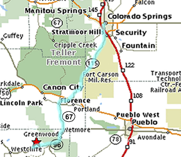
Bear Basin Ranch is located in Custer County, Colorado (about 1.5 hours south and west of Colorado Springs). The ranch is nestled in the heart of the Wet Mountains, which overlook the Wet Valley to the west and run parallel to the Sangre de Cristo National Wilderness Area. About 20 minutes away to the west, in the center of the Wet Valley lies Westcliffe, the capitol of Custer County.
. .. Custer County
Located in south central Colorado, Custer County is one of the least populous counties in the state. At an average elevation of 7,888 feet, the county stretches from the heights of the Sangre De Cristo Mountains on the west to the heights of the Wet Mountains on the east, and from the rim of the Arkansas River Valley on the north to the rim of the Huerfano River Valley to the south.County residents include a mixture of cattle ranchers and hay growers, folks who enjoy rural mountain living, and of course, the folks who live in the towns. Over the past decade, our population has expanded to include a large number of "retirees," some year 'round residents, and others with summer homes. The fresh mountain air, clear skies, and friendly people make this Valley a favorite for folks from all over the world. Hiking trails are numerous, many leading to a secluded lake where fishing becomes a real joy. According to the U.S. Census, the population of Custer County in 2000 was about 3,500 - that's about 4.7 people per square mile!
Westcliffe
Westcliffe, and the adjoining town of Silver Cliff, were founded during the mining days of the late 1800's. Gold and silver were found on the site of the Ghost town "Rosita" which is located about 10 miles southeast of Westcliffe. The town of Rosita quickly grew to have a population of more than 3,000 hardy individuals.
Not long after, a major silver strike was made lower down in the Valley and Silver Cliff was born. The mining activities in the Valley grew to such proportions that Railroad spur lines were brought into the Valley from the north - initially along Grape Creek and later from Texas Creek. In the years that followed, after the mines played out, only Silver Cliff and Westcliffe survived. Today, the estimated populations of Westcliffe and Silver Cliff combined is about 2,000 people.
Sangre de Cristo National Wilderness Area
The Sangre de Cristo Mountains are one of the longest mountain chains on Earth. The mountains were pushed up about 27 million years ago, pretty much as one big chunk of rock. With major fault lines running north-south along both sides of the range, the Sangres stretch from Poncha Pass, Colorado, in the north to Glorieta Pass, New Mexico, in the south. On the west side is the San Luis Valley - a flat, unbroken plot of ranch and farmland the size of the state of Connecticut with the Rio Grande river running right down the middle. On the east side is the Wet Valley and the Raton Basin with a quiet but still active volcanic field.There are ten peaks over 14,000' high in the range, and more than two dozen over 13,000'. Miles and miles of excellent alpine hiking trails through millions of acres of the San Isabel, Rio Grande, Carson, and Santa Fe National Forests. The Sangre de Cristo, Wheeler Peak, Latir Peak, Pecos, and Spanish Peaks Wilderness Areas are found here, as well as Great Sand Dunes National Park. Some of the best rock climbing, snow skiing and whitewater rafting on Earth are also right here. The Trinchera elk herd is one of the largest in the world. Rocky Mountain Bighorn Sheep are found all through the range and Fly Fisherman enjoy the Gold Medal waters.
Distances from Surrounding Cities and Towns
Canon City, 46 miles, Driving time: 1 hour
Colorado Springs, 80 miles, Driving time: 1.5 hour
Pueblo, 55 miles, Driving time: 1 hour
Salida, 58 miles, Driving time: 1 hour
Walsenburg, 65 miles, Driving time: 1.25 hour
Denver, 149 miles, Driving time: 2.5 hour
. .Directions to the Ranch (From COLORADO SPRINGS)
- South on I-25 to the Nevada Ave. exit for Hwy 115.
- South on 115 from Colorado Springs to Florence.
- At the first light in Florence (Carl's Junior), left (south) onto Hwy. 67 to Wetmore.
- At the T-intersection in Wetmore, right (Southwest) onto Hwy. 96.
- Up and over the pass, veer right at the top of the pass, and continue through the valley out to the plain (watch out for elk!)
- About mile marker 11, turn right (North) onto County Road 271.
- Bear Basin Ranch is ¼ mile down on your left.
.Home I Location I History I Outfitters I Contact Us,